This section has a completely new alignment for the canal. The 1961 beach occurred on a bend to the east of the proposed new line in this area. This bend was completely removed during landscaping work after the canal closed. The new route follows a straight line immediately to the east of a proposed development area. Midway along this section a public footpath from Newport Lane arrives on the offside of the canal as part of the Two Saints Way pilgrimage route from Chester to Lichfield..
Detailed description
The proposed re-aligned section follows the line of the present walkway along the edge of the valley. Land may need to be acquired to the west of the canal as the embankment is not stable enough to the east to allow the canal to be positioned right on the edge. However the presence of the canal will give the adjacent landowner the opportunity to create new canalside residences with spectacular views over the water into the valley and towards The Grange. A challenge in any such project is that the land levels rise significantly to the west so re-profiling will be needed to get the best from any such development.
To improve stability the canal in this area will be constructed as a concrete box section. It is presently thought that it will be constructed to take one boat (making the channel approximately 3 metres wide) but negotiations with the adjacent landowner may change this. Waiting areas will need to be provided for boaters immediately to the north and south of this area.
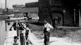
The towpath will be to the east of the canal. There is a sharp drop to the east, so it may be necessary to provide fencing or some other safety measure. It is anticipated that the towpath in this area will form part of a new cycle route from Middleport through to Festival Park so consideration needs to be given to the conflicting needs of users of the towpath in this relatively narrow area. The footpath from Newport Lane gives an opportunity for a small public space to break up the line of any new housing development. This is the former boatyard area, though no trace remains, and the land levels lend themselves to a public open space beside the canal.
A footbridge over to the towpath may need to be provided in this area as the one to the east on the Trent & Mersey Canal has long gone..
Landowners
The proposed canal bed is owned by Stoke-on-Trent City Council and Severn Trent Water.
Stakeholders
Boaters, local community, walkers, cyclists.
Delivery
This is technically the most difficult section of the canal to build. Careful calculations will need to be made to ensure that the new section of canal does not slip. There is no obvious scope for volunteer-led activity in this area.